
In chapter 10, “Geospatial Querying”, of the book “Building Real-Time Analytics Systems” [1], authors provide an overview of real-time status tracking of delivery vehicles, using a hypothetical example of a pizza delivery company.
What enables efficient querying of geospatial location data is geospatial indexing. Since the proposed architecture leverages Apache Pinot, the geospatial index is based on Uber’s Hexagonal Hierarchial Spatial Index library.
The underlying logic has been nicely explained in the book:
“This library provides hexagon-based hierarchical gridding. Indexing a point means that the point is translated to a geoId, which corresponds to a hexagon. Its neighbors in H3 can be approximated by a ring of hexagons. Direct neighbors have a distance of 1, their neighbors are at a distance of 2, and so on.
For example, in Figure 10-2, if the central hexagon covers the centre of Bangalore, neighbors at distance 1 are colored blue, those at distance 2 are in green, and those at distance 3 are in red.”
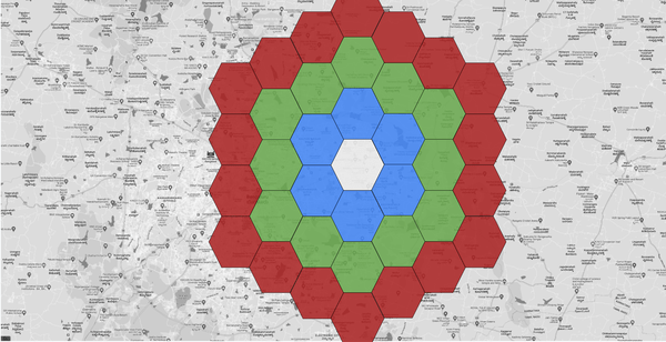
Image source: Building Real-Time Analytics Systems- Mark Needham, O’Reilly Media Inc.
Now geospatial indexing can be of many forms (like lat/long or geographical shapes), but reviewing this specific HHS index and how it can be leveraged, made me think about extrapolating this approach to warehouse analytics. Specifically, its application allows routing pickers in real-time in a warehouse.
In high-volume e-commerce scenarios, orders consistently and continuously stream into a warehouse. Much like how people keep on requesting rides through the Uber app.
And just like a ride, the three key elements here are:
- The passenger (order item(s)’) current location in the warehouse
- The driver’s (Picker’s) location in the warehouse
- The passanger’s (order item(s)’) final location in the warehouse
This is an extreme simplification to highlight the possibilities of extrapolating the approach. For example, each order may have multiple items located in multiple different aisles. The destination conveyor location can also be optimized based on outbound transportation doors/docks.
But the gist is this approach of overlaying the hexagon layout on the warehouse layout to leverage the same geospatial indexing is feasible.
This can help push real-time flow routing of manual picking feasible and can also help generate more efficient routes for bot-picking environments. But a bigger and more potent approach can be combining this approach with real-time supply chain visibility data to generate insights and build solutions that currently do not exist.
References:
[1] Book: Building Real-Time Analytics Systems- Mark Needham, O’Reilly Media Inc.
